


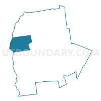
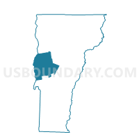
Addison Voting District, Addison County, Vermont
About
Outline

Summary
| Unique Area Identifier | 680693 |
| Name | Addison Voting District |
| County | Addison County |
| State | Vermont |
| Area (square miles) | 48.93 |
| Land Area (square miles) | 41.53 |
| Water Area (square miles) | 7.40 |
| % of Land Area | 84.87 |
| % of Water Area | 15.13 |
| Latitude of the Internal Point | 44.05853920 |
| Longtitude of the Internal Point | -73.33231460 |
Maps

Graphs
Select a template below for downloading or customizing gragh for Addison Voting District, Addison County, Vermont


Neighbors
Neighoring Voting District (by Name) Neighboring Voting District on the Map
- Voting District 020001 020003, Essex County, NY
- Voting District 090004, Essex County, NY
- Bridport Voting District, Addison County, VT
- New Haven Voting District, Addison County, VT
- Panton Voting District, Addison County, VT
- Waltham Voting District, Addison County, VT
- Weybridge Voting District, Addison County, VT
Top 10 Neighboring County Subdivision (by Population) Neighboring County Subdivision on the Map
- Moriah town, Essex County, NY (4,798)
- Crown Point town, Essex County, NY (2,024)
- New Haven town, Addison County, VT (1,727)
- Addison town, Addison County, VT (1,371)
- Bridport town, Addison County, VT (1,218)
- Weybridge town, Addison County, VT (833)
- Panton town, Addison County, VT (677)
- Waltham town, Addison County, VT (486)
Top 10 Neighboring Elementary School District (by Population) Neighboring Elementary School District on the Map
- Vergennes Union High School District 44, VT (3,751)
- New Haven School District, VT (1,727)
- Addison School District, VT (1,371)
- Bridport School District, VT (1,218)
- Weybridge School District, VT (833)
Top 10 Neighboring Secondary School District (by Population) Neighboring Secondary School District on the Map
- Middlebury Union High School District 3, VT (14,721)
- Mount Abraham Union High School District 28, VT (10,649)
- Vergennes Union High School District 5, VT (7,897)
Top 10 Neighboring Unified School District (by Population) Neighboring Unified School District on the Map
Top 10 Neighboring State Legislative District Lower Chamber (by Population) Neighboring State Legislative District Lower Chamber on the Map
- Assembly District 113, NY (135,737)
- Addison-3 State House District, VT (7,897)
- Addison-5 State House District, VT (3,778)
Top 10 Neighboring State Legislative District Upper Chamber (by Population) Neighboring State Legislative District Upper Chamber on the Map
Top 10 Neighboring 111th Congressional District (by Population) Neighboring 111th Congressional District on the Map
Top 10 Neighboring Census Tract (by Population) Neighboring Census Tract on the Map
- Census Tract 9609, Addison County, VT (5,337)
- Census Tract 9604, Addison County, VT (5,094)
- Census Tract 9610, Essex County, NY (4,798)
- Census Tract 9611, Essex County, NY (2,024)